


Request A Free Travel Guide
The Flagstaff Travel Guide is an annual publication featuring the accommodations, restaurants, activities and useful travel information for the Flagstaff area.
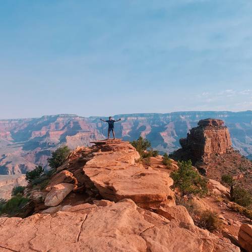
Get The GuideWith the highest mountain in Arizona and Grand Canyon in its back yard, Flagstaff is an outdoor recreation paradise.
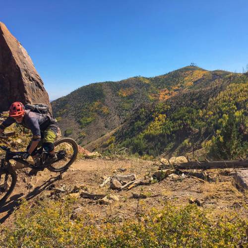
The entire region boasts amazing hiking, running, biking, and rock climbing. Flagstaff is a hiker’s paradise with trails available for all skill levels. When exploring the backcountry, remember to bring plenty of water, snacks, a trail map, sunscreen, wear layered clothing, a hat and comfortable shoes. It’s also a good idea to let someone know where you are going and plan to return. Be safe and have fun!
If you think you've peaked, we’ve got plenty more that are green and less unseen! Flagstaff offers an abundance of trails to choose from. Whether you’re just getting into hiking, taking your bike out for a spin or have a stroller tagging along, we’ve got a trail for you!
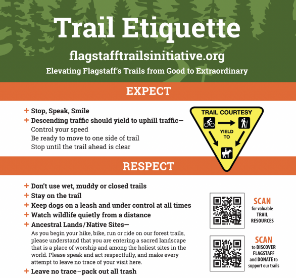
All leashed dogs welcome!


Difficult, Generally considered a challenging route, it takes an average of 4 h 24 min to complete. The trail is open year-round and is beautiful to visit anytime. Dogs are welcome, but must be on a leash.

Moderate, Generally considered a moderately challenging route, it takes an average of 7 h 4 min to complete. This is a popular trail for backpacking, camping, and hiking, but you can still enjoy some solitude during quieter times of day. Dogs are welcome, but must be on a leash.

Moderate, Generally considered a moderately challenging route, it takes an average of 2 h 4 min to complete. This trail is great for birding, biking and hiking. The trail is open year-round and is beautiful to visit anytime.

Moderate, Generally considered a moderately challenging route, it takes an average of 4 h 31 min to complete. The trail is open year-round and is beautiful to visit anytime. Dogs are welcome, but must be on a leash.

Difficult, Generally considered a moderately challenging route, it takes an average of 4 h 52 min to complete. The trail is open year-round and is beautiful to visit anytime. Dogs are welcome, but must be on a leash.

Easy, Have you always wanted to know what it feels like to walk around barefoot in the great outdoors? Use all your senses while barefoot to experience this manicured 1-mile trail through dirt, mud, water, sand, stone, and rocks. Try out the adventure stations along the way and challenge your mind and body while grounding!

Moderate, Visit the Arizona Nordic Village in summer and get your fill of wildlife, wildflowers, monsoon, and green! During the summer, trails are open for hiking, biking, horse riding, wildlife viewing, and so much more.

Easy, Generally considered a moderately challenging route, it takes an average of 5 h 53 min to complete. This trail is great for backpacking, camping, horseback riding, and hiking. The best times to visit this trail are in Spring, Summer, and Fall.

Difficult, Generally considered a challenging route, it takes an average of 5 h 39 min to complete. This trail is great for hiking, horse riding, and mountain biking.

Moderate, Generally considered a moderately challenging route, it takes an average of 6 h 0 min to complete. This is a popular trail for backpacking, camping, and hiking, but you can still enjoy some solitude during quieter times of the day. The best times to visit this trail are April through November. Dogs are welcome but must be on a leash.

Easy, Picture Canyon Natural and Cultural Preserve is generally considered an easy and great place to hike, mountain bike, horseback ride, photograph the natural environment, watch wildlife, experience fall colors, and discover cultural resources, including petroglyphs. The Preserve is open to the public year round.

Easy, Generally considered an easy route, it takes an average of 57 min to complete. Dogs are welcome on-leash and this trail is kid-friendly as well.

Easy, Generally considered an easy route, it takes an average of 25 min to complete. This is a popular trail for hiking and walking, but you can still enjoy some solitude during quieter times of day. The best times to visit this trail are April through September. Dogs are welcome, but must be on a leash.

Difficult, Generally considered a challenging route, it takes an average of 3 h 17 min to complete. This trail is great for hiking, mountain biking, running, and horseback riding. The best times to visit this trail are May through October. However, you'll need to leave pups at home — dogs aren't allowed on this trail.

Moderate, Generally considered a moderately challenging route, it takes an average of 1 h 42 min to complete. Dogs are welcome, but must be on a leash.

Difficult, Generally considered a challenging route, it takes an average of 5 h 30 min to complete. The trail is open year-round and is beautiful to visit anytime. Dogs are welcome, but must be on a leash.

Easy, Try this 0.5-mile loop trail near Bellemont, Arizona. Generally considered an easy route, it takes an average of 9 min to complete. This is a popular trail for birding and walking, but you can still enjoy some solitude during quieter times of day. The best times to visit this trail are March through November. Dogs are welcome, but must be on a leash.

Difficult, Generally considered a moderately challenging route, it takes an average of 4 h 55 min to complete.

Moderate, Generally considered a moderately challenging route, it takes an average of 5 h 22 min to complete. This trail is great for hiking, horseback riding, and mountain biking. The best times to visit this trail are April through November. Dogs are welcome, but must be on a leash.

Moderate, Generally considered an easy route, it takes an average of 1 h 10 min to complete. The best times to visit this trail are April through October. Dogs are welcome, but must be on a leash.

Moderate, Generally considered a moderately challenging route, it takes an average of 2 h 8 min to complete. This is a popular trail for birding, hiking, and mountain biking, but you can still enjoy some solitude during quieter times of day. The best times to visit this trail are May through October. Dogs are welcome, but must be on a leash.

Easy, Generally considered an easy route, it takes an average of 1 h 23 min to complete. This is a very popular area for hiking and mountain biking, so you'll likely encounter other people while exploring. Dogs are welcome, but must be on a leash.

Moderate, Generally considered a moderately challenging route, it takes an average of 3 h 0 min to complete. Dogs are welcome, but must be on a leash.

Easy, Generally considered an easy route, it takes an average of 45 min to complete. This is a popular trail for hiking, biking, and running, but you can still enjoy some solitude during quieter times of day. The trail is open year-round and is beautiful to visit anytime. Dogs are welcome on-leash.

Easy, Surrounded by ponderosa forest at 7,150 feet in elevation with spectacular views of the San Francisco Peaks, The Arboretum at Flagstaff is a unique destination, specializing in increasing the understanding, appreciation and conservation of plants native to the Colorado Plateau. Home to 750 species of plants and countless wildlife, take a leisurely stroll through our beautiful 200-acre property consists of gardens, greenhouses, wetlands, and woodlands. Interpretive signage about the ecology of the region, encounters with wildlife and photo ops occur throughout the 2 miles of family and pet friendly trails. Be sure to take a memorable photo at The Discover Flagstaff photo frame with the iconic San Francisco Peaks as a backdrop. Admission fees and visitor information can be found on our website.

Easy, Generally considered an easy route, it takes an average of 1 h 53 min to complete. This is a very popular area for birding, hiking, and mountain biking, so you'll likely encounter other people while exploring. The best times to visit this trail are April through September. Dogs are welcome but must be on a leash.

Moderate, Generally considered a moderately challenging route, it takes an average of 1 h 39 min to complete. The best times to visit this trail are March through November. Dogs are welcome, but must be on a leash.

Easy, Generally considered an easy route, it takes an average of 1 h 9 min to complete. This is a very popular area for hiking, mountain biking, and running. The best times to visit this trail are April through November. Dogs are welcome on-leash.

Moderate, This route takes an average of 1 h 1 min to complete. Dogs are welcome, but must be on a leash.

Difficult, Generally considered a moderately challenging route, it takes an average of 1 h 24 min to complete. This is a very popular area for hiking, biking and running, so you'll likely encounter other people while exploring.

Easy, Generally considered an easy route, it takes an average of 44 min to complete. This is a very popular area for birding, hiking, and mountain biking, and is accessible to all, so you'll likely encounter other people while exploring. The best times to visit this trail are March through November. Dogs are welcome, but must be on a leash.

Easy, Generally considered an easy route, it takes an average of 1 h 53 min to complete. This is a popular trail for birding, hiking, and mountain biking, but you can still enjoy some solitude during quieter times of day. The best times to visit this trail are April through October. Dogs are welcome, but must be on a leash.

Lava Flow Trail, Moderate • .9 miles, 20 min
Paved Lava Flow Trail, Easy • .4 miles, 7 min
A'Ah Lava Trail, Easy • .2 miles, 3 min
Bonito Vista Trail, Easy • .3 miles, 5 min
Lava's Edge Trail, Easy • 3.6 miles, 1 hr 12 min

Moderate, 9.3-mile out-and-back. Generally considered a moderately challenging route, it takes an average of 4 h 9 min to complete. This trail is great for hiking, and it's unlikely you'll encounter many other people while exploring. Dogs are welcome, but must be on a leash.

Moderate, 5.5-mile loop. Generally considered a moderately challenging route, it takes an average of 2 h 52 min to complete. This is a popular trail for hiking and mountain biking, but you can still enjoy some solitude during quieter times of day. The best times to visit this trail are May through October. Dogs are welcome, but must be on a leash.

Easy-Moderate, 1.5 miles, one way. Generally considered a moderately easy route, it takes an average of 3 h 30 min to complete. Dogs are welcome, but must be on a leash.

Easy-Moderate, 1.2 miles, one way. Dogs are welcome, but must be on a leash.

Difficult, 1.6 miles, one way. Dogs are welcome, but must be on a leash.

Easy, 2.9 miles, one way.

Easy, 1.1 miles, one way.
The Flagstaff Travel Guide is an annual publication featuring the accommodations, restaurants, activities and useful travel information for the Flagstaff area.
Get The Guide