The Arizona National Scenic Trail
As published by Lonely Planet
One of the nation’s most rewarding long distance trails, the Arizona National Scenic Trail climbs and descends no less than ten rugged mountain ranges and the world’s grandest of canyons, repeatedly traversing mountain peaks, deep gorges, forested landscapes, riparian corridors, and countless wilderness expanses. While it teems occasionally with iconic Saguaro cacti and other prickly Sonoran Desert succulents, it offers 800 miles of so much more. Be warned, if the word “desert” preceded by the word “vast” describes your preconceived mental image of the AZT, you may not be grasping the Arizona Trail’s full, sweeping diversity.
To challenge your assumptions, let’s begin at the Mexico border. Here, where a barbed wire fence separates the U.S. from Mexico, the AZT trailhead perches at a breezy 5,900ft in elevation. Less than 6.5 miles from the start, the footpath rockets immediately up to the top of Miller Peak at 9,090 feet, capped in deep snow for much of the winter. At it’s lowest, the AZT briefly dips to 1,650 ft just outside of Superior, AZ, but the overall average elevation hovers around 5,000ft. And so goes the AZT, up and down, over and over, for nearly 800 miles.
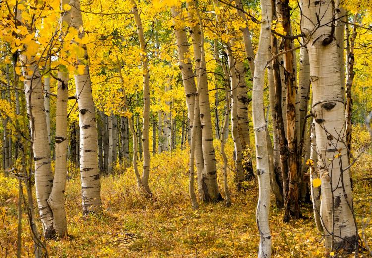
In northern Arizona’s high country, the trail is crowned with firs, aspen patches, and the world’s largest stand of ponderosa pine. South of Flagstaff the AZT dives into a shag carpet of juniper-chaparral woodlands. Sedona’s red rocks intermingle with dramatic canyon fissures and endless ribbons of distant purple mountains (several of which you’ll summit along your path). Eventually, these mesas descend into an alien desert floor, toy soldier-green with bountiful life. Saguaros cover the landscape like stubble on a chiseled jaw. Lush palo verdes, their bark brightly lime-colored, fill the washes and canyons. The rocky soils hide beneath endless prickly pear, teddy bear cholla, and jojoba. Creosote bushes climb the hills, smelling of rolling thunder and desert rain.
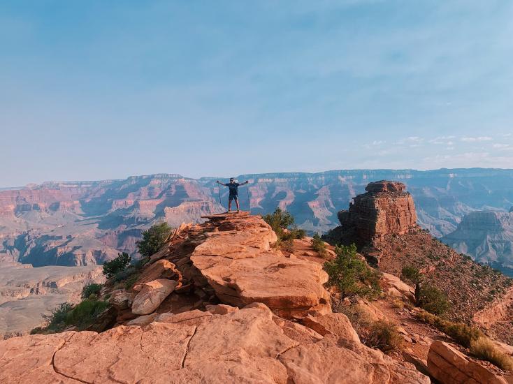
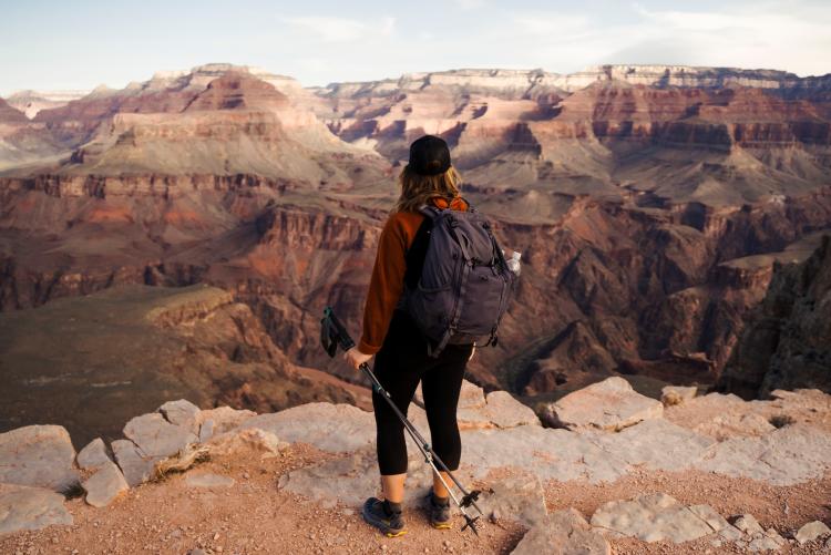
Have we mentioned the World Wonder along your route? To explore the length of Arizona, it is necessary to explore its depth. The Grand Canyon contains a kaleidoscope of ecozones. Dropping from the rim to river, you’ll move from snow-patched, mixed conifer forest through ponderosa pine, through a juniper-oak woodland and a sagebrush plateau, and finally into desert scrub, complete with shocking heat. The average 60-day through-hike across the state requires leaping and climbing and stumbling through every one of these ecotypes, but here you can experience them all in a single day. It’s as if someone has taken the full sweeping diversity of the Arizona Trail and collapsed it into, well, Cliffs Notes.
Close your eyes and imagine for a moment taking 8 or 10 weeks to through-hike these roadless vistas. Only your two feet pull you forward, over the course of changing seasons. You have enough time between the endless risings and settings of Arizona’s fiery sun to actually stop and smell the wildflowers and cactus blossoms, and to really taste water in your throat, precious and hard-fought between moments of natural scarcity. You flush unsuspecting javalinas and bobcats and coyotes from their shady resting spots as you pass, occasionally stepping over giant black bear scat. You stand atop the summit you’ve just ascended and turn and see nothing but nature. You rest in silence with a sense of smallness and insignificance, imagining a planet without us, and dare to ponder your miraculous but minuscule part in the cosmos.
Conceptually broken into 43 distinct “passages,” today the AZT offers serious long distance-trekkers and casual day hikers countless opportunities to be transported back in time to landscapes unburdened by the staples of modern humanity. The solitude that so many hikers seek in the wilderness (sometimes elusive along other National Scenic Trails) can still be found in abundance. Whether you’re through-hiking, day hiking, or slowly completing the trail in segments, countless trailheads offer convenient on-and-off access.
Water is the through-hiker’s single greatest challenge, but numerous resources and strategies abound all along the trail to help thirsty explorers cope. Supplies you cache for yourself along the route will be left alone. Apps allow hikers to communicate info to each other about the location and quality of water along the way.
The Arizona Trail owes its legacy to Flagstaff schoolteacher Dale Shewalter, who envisioned an interconnected, non-motorized path between Mexico and Utah back in the 1970s. He finally walked the length of the state on foot in 1985, exploring the routes that might be suitable to realizing his vision. Thanks to his advocacy, that vision was gradually embraced by cities and towns, state parks, national forest managers, and the National Parks Service. Avid hikers, bikers, and horseback riders throughout the state took ownership of this national amenity and connected all the dots.

Accommodations
The AZT is particularly remote throughout (and proud of it), physically passing through very few population centers. However, there are 29 designated “gateway communities” along the AZT, and accommodations and AZT discounts are available in each. Through-hikers are welcome to mail packages to themselves in all of the communities nearest the trail. Day hikers will find resources and respite in any of the designated gateways, as well. Listed below, from south to north, are a very select number of accommodations that cater to both through-hikers and afternoon jaunters simply looking for a gorgeous nearby trek:
Patagonia (Mile 50): Stage Stop Inn - This inn was once a bonafide, rootin-tootin stage stop along the historic Butterfield Trail. Several places to eat are nearby. Arizona Trail discounts available.
Superior (Mile 300): Copper Mountain Motel - Family run, and promises a “swanky, irresistible vibe that makes each guest feel like a celebrity…”
Pine (Mile 460): That Cabin at That Brewery & Pub - A bed with your brew? Or vice-versa? “That” sounds like a well-earned treat!
Jacob Lake (Mile 760): Jacob Lake Inn - 2 miles from the trail, it’s worth the detour, with rooms, a restaurant, a store, and the best fresh-baked cookies north of the Grand Canyon!
Highlights
Grand Canyon North Rim: Seasonally closed to cars, the North Rim may feel like yours alone if you make it here on your own feet!
The world’s largest Ponderosa forest: From the Grand Canyon’s south rim, to the Mogollon Rim, the AZT cuts through 203 miles of Ponderosa pine country.
The Sonoran Desert: It dominates the southern half of the AZT. Try hiking by moonlight, and you might find the trail bustling with active wildlife.
White-Canyon Wilderness: A vast wilderness experience replete with the perennial Gila River. Keep an eye out for mountain lion tracks as you scramble the arroyos.
The Pusch Ridge Wilderness: Hovering above Tucson at 6,000 ft, this forested wonderland of stately rock formations feels like a labyrinth. Bring a good map!
Resources
- The Arizona National Scenic Trail Association
- The Official Arizona Trail App
- Grand Canyon National Park
- Saguaro National Park

Trail Sections or Highlights
The Grand Canyon:
With historic lodges and visitor’s centers and established camping on both rims, and with the iconic Phantom Ranch in the middle along the bottom, Grand Canyon National Park exerts an enormous and unforgettable presence as the preeminent highlight of the AZT. Permits and advance planning are a must. Even if you’re in shape enough to hightail it rim-to-rim in a single day, (a 21 mile feat), the north and south park boundaries are 40.2 miles apart, and at-large camping without a permit is, well…not permitted. But why rush this section of the trail? GCNP offers a perfect excuse to relax and smell the flowers. Allow several days for your visit and check out a few of the countless side trails and scenic adventures throughout.
Flagstaff, AZ:
The AZT cuts right through town. A tourist destination all its own, Flagstaff makes a great basecamp for casual day hikers and wearier through-hikers looking for a place to wash clothes and grab a civilized meal. Be sure to check out Lowell Observatory, where recently down-graded dwarf planet Pluto was discovered. Nearby, three National Monuments will reward day explorers with truly delightful and unique visits. Walnut Canyon boasts of cliff dwellings peppering the sides of deep gorges. Sunset Crater will transport visitors to a pleasant but alien volcanic landscape that feels far more Hawaiian than Southwestern. And Wupatki National Monument is a cultural delight with impressive and large-scale native American pueblos and a truly otherworldly “blow hole” that has to experienced to be appreciated.
Saguaro National Park, Colossal Cave, and Biosphere II:
Skirting the east side of Tucson, Saguaro National Park will challenge your assumptions, too. Saguaros? Well, yeah. But the park contains one of the AZT’s toughest vertical profiles, marching you in 13 miles through epic views up from 3,000ft in elevation and into a thick pine forest at 8,600ft. And since you’re passing through nearby Colossal Cave Mountain Park anyway, you might as well pop in and enjoy the cool interior of a cave with lots of colorful history.
North of the Catalina Mountains, the AZT offers a bird’s-eye view of the white geometric structures of Biosphere II. A touristy visit would probably require a cab or ride-share from the town of Oracle. Well worth it if you’re due for a rest day anyway.
Published by Lonely Planet